The geology of the Blindern campus area
Øyvind Hammer, UiO
Introduction
The area around the University of Oslo campus at Blindern has a rich and varied geology. Although there are of course better localities outside the built-up areas in the Oslo region, the Blindern area provides more than enough geology for a basic introduction to field geology and a number of geological processes. In addition, it demonstrates how the bedrock geology influences human activity, and may give students a new view on their everyday surroundings.
I have chosen five localities for a two-hour "field trip". There are, however, several other good exposures in the area. If you find interesting geological phenomena that are not described here, then please contact me!
Geological background
The exposed geology in the area is basically a product of four historical phases:
- Marine sedimentation of shales and carbonates in the mid Ordovician, about 470-460 million years ago.
- Folding of these strata during the Caledonian orogen in the Devonian, ca. 400 million years ago.
- Rifting and volcanic activity in the Carboniferous-Permian, around 280 million years ago.
- Glacial erosion in the Pleistocene (Ice Ages) and marine sedimentation in the Holocene.
The Caledonian folds mainly follow a SW-NE strike direction, reflecting the prevalent fold direction in the Oslo region. The folding pressure came from NW. Where limestone horizons crop out along strike, characteristic limestone ridges are found, while the shaly parts are more easily eroded and are now mainly covered with marine Holocene clays in the valleys. Hence, the topography and many of the roads follow the SW-NE direction. In this way, the main axis of the campus is a reminder of the collision of Baltica and Laurentia (North America-Greenland) in the Devonian.
The Carboniferous-Permian rifting activity is mainly reflected in the numerous magmatic dykes, often in a N-S direction (normal to the E-W extension), forming ridges in the terrain. Intersections between limestone outcrops and dykes form pronounced hills.
Localities
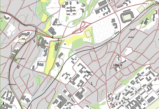
(Map from Arealis, NGU)
Locality 1: Hasselhaugveien
Ordovician shales, limestones and nodular limestones, dipping to the NW. Students measure strike and dip.
Locality 2: Problemveien, by Forskningsparken train station
Good section of Ordovician massive and nodular limestones (possibly Frognerkilen Formation?). Dip still to the NW, and we may be on the same fold flank as Loc. 1.
Locality 3: Footpath on the inside of Ring 3, left of entrance to tunnel under the Ring
Shale with large, scattered limestone nodules of a slightly reddish colour. Dip is now to the SE. This may be the other flank of the large fold (syncline). Pairs and triples of large cystoids (Echinosphaerites?), which were spherical, sessile echinoderms ("sea urchin on a stalk"). These fossils are partly filled with calcite crystals. Parts of trilobites.
Locality 4: Road cutting in Ring 3, north side
This locality is a bit noisy. Going eastwards from the bridge, we see several small, pretty folds. Below a steel bolt (marker) is a little anticlinal fold which has detached from the underlying horizontal strata. This is called a "decollement". The fold has slipped along a very thin, greenish layer of loose material. This is a bentonite - volcanic ash from a large eruption in the Ordovician.
A few meters further to the east is a large dyke, with a smaller one to the side.
Locality 5: Slemdalsveien, inside Ring 3
A colossal dyke of "rhombic porphyre", 25 meters wide. This dyke can be followed southwards to Frognerparken, and also for some distance northwards. A green sign explains the geology, although the ages in millions of years are a bit off.
You can now walk through Forskningsparken back to the university. If you take the foot bridge across the train line, you can see some outcrops of Ordovician rocks along the train line, dipping NW as on Locs. 1 and 2. A small dyke crosses the foot path on the top of the hill past the train line.
Other localities in the area
A large dyke is found on the south side of Blindernveien just below the Institute of Geosciences.
Smaller dykes on the south side of the Institute of Chemistry, some with nice glacial erosional features (stripes and "whale rock").
Large road cuttings with folds in Sognsveien and Ring 2 by Vestre Aker church.